|
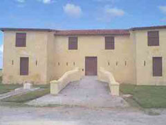
BIRTH HOUSE OF JOSÉ ANTONIO ECHEVERRÍA
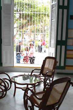 It is located on Genas St. No.560 between Calzada and Colonel Verdugo, municipality of Cárdenas, only 10 miles away from the famous beach of Varadero.
This cultural institution was declared a National Monument since 1971 due to its historical and architectural values. Inside the building there are 983 objects on exhibit.
It has nine rooms, one of them decorated in a way that recreates the childhood period of José Antonio, exhibiting furniture that although did not originally belong to the family, it does date from that time.
Also quite notable for the visitor is the painters palette that he used as a child, his notebook with the addresses of envelope collectors, as well as the Chrysler automobile, manufactured in 1954 which he used for smuggling rifles and revolutionaries, while studying Architecture in the University of Havana, during the struggle against the regime of Fulgencio Batista.
It is located on Genas St. No.560 between Calzada and Colonel Verdugo, municipality of Cárdenas, only 10 miles away from the famous beach of Varadero.
This cultural institution was declared a National Monument since 1971 due to its historical and architectural values. Inside the building there are 983 objects on exhibit.
It has nine rooms, one of them decorated in a way that recreates the childhood period of José Antonio, exhibiting furniture that although did not originally belong to the family, it does date from that time.
Also quite notable for the visitor is the painters palette that he used as a child, his notebook with the addresses of envelope collectors, as well as the Chrysler automobile, manufactured in 1954 which he used for smuggling rifles and revolutionaries, while studying Architecture in the University of Havana, during the struggle against the regime of Fulgencio Batista.
Pour davantage d'information:
www.cuba-heroes.com
,
www.cuba-history.com
,
www.cuba-museums.com
,
www.cuba-matanzas.com
,
www.cubanphotobank.com
|
|
|
CAIMITO DEL HANÁBANA
This area maintains its original name and has a high historical value, due to the fact that it is where the first human settlements were made. As early as 1536 the metropolis donated some portions of land to the Spanish settlers from the Peninsula, where they made their home for many years.
The historical value of this place is outstanding, one of the events that took place here was on October 23rd of 1862, when José Martí at the age of nine, wrote a letter to his mother Doña Leonor Pérez, during his stay in Caimito del Hanábana. This letter was considered the first written work of the master and it is the oldest letter preserved to date.
Caimito del Hanábana is one of the five Captaincies of the Party belonging to the jurisdiction of Colón City, a present day municipality of the province of Matanzas. The visitor can always find an open invitation to encounter the history of this place which is considered a National Monument.
Pour davantage d'information:
www.cuba-history.com
,
www.cuba-josemarti.com
,
www.cuba-literature.com
,
www.cuba-matanzas.com
|
|
|
CAVE OF SANTA CATALINA
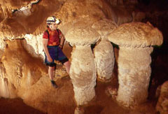 Featuring an attractive environment, this cave is found along the road that leads into the city of Matanzas and to Varadero beach, exactly four kilometres east of the town of Carbonera.
This natural site was declared a National Monument in 1996. It is characterised by eleven kilometres of subterranean galleries and features the most extraordinary secondary formations, especially interesting are the mushrooms, zinolites and aboriginal pictographs.
Nearby, there is another place known as the Cave of the Dead (Cueva del Muerto), right next to the drawbridge of Varadero. It is a cave of great natural and archaeological value, due to the fact that in over eight kilometres of galleries there is ample evidence of pre-Columbian communities and many species of fauna and secondary formations.
Featuring an attractive environment, this cave is found along the road that leads into the city of Matanzas and to Varadero beach, exactly four kilometres east of the town of Carbonera.
This natural site was declared a National Monument in 1996. It is characterised by eleven kilometres of subterranean galleries and features the most extraordinary secondary formations, especially interesting are the mushrooms, zinolites and aboriginal pictographs.
Nearby, there is another place known as the Cave of the Dead (Cueva del Muerto), right next to the drawbridge of Varadero. It is a cave of great natural and archaeological value, due to the fact that in over eight kilometres of galleries there is ample evidence of pre-Columbian communities and many species of fauna and secondary formations.
Pour davantage d'information:
www.cuba-fauna.com
,
www.cuba-flora.com
,
www.cuba-geography.com
,
www.cuba-history.com
,
www.cuba-varaderobeach.com
,
www.cuba-matanzas.com
|
|
|
CIÉNAGA DE ZAPATA
 Les amoureux de la nature ont dans cette portion sud-est de Cuba un lieu obligé de visite pour admirer les forêts presque vierges et ses plages aux eaux bleues et transparentes, ses lacs et ses grottes, ainsi que ses piscines naturelles. Ici vit 30 pour cent de la faune autochtone, des 171 oiseaux, 18 sont endémiques de lîle. Il y a en plus une grande variété de crocodiles, arrivant approximativement à 1 500 exemplaires, en plus du Manati considéré comme un joyau de la faune nationale.
Le Centre International dObservation des Oiseaux se trouve à Playa Larga, avec 400 mètres deaux tièdes et des fonds coralliens et des sentiers naturels.
Le centre touristique de Guama est une construction aborigène où le travail de la fameuse artiste cubaine Rita Longa peut être apprécié dans toute sa magnitude.
Playa Giron (la plage de Giron) marqua en 1961 la déroute des forces mercenaires payées par le États-Unis dAmérique qui envahirent Cuba par cette zone.
Les amoureux de la nature ont dans cette portion sud-est de Cuba un lieu obligé de visite pour admirer les forêts presque vierges et ses plages aux eaux bleues et transparentes, ses lacs et ses grottes, ainsi que ses piscines naturelles. Ici vit 30 pour cent de la faune autochtone, des 171 oiseaux, 18 sont endémiques de lîle. Il y a en plus une grande variété de crocodiles, arrivant approximativement à 1 500 exemplaires, en plus du Manati considéré comme un joyau de la faune nationale.
Le Centre International dObservation des Oiseaux se trouve à Playa Larga, avec 400 mètres deaux tièdes et des fonds coralliens et des sentiers naturels.
Le centre touristique de Guama est une construction aborigène où le travail de la fameuse artiste cubaine Rita Longa peut être apprécié dans toute sa magnitude.
Playa Giron (la plage de Giron) marqua en 1961 la déroute des forces mercenaires payées par le États-Unis dAmérique qui envahirent Cuba par cette zone.
Pour davantage d'information:
www.cuba-giron.com
,
www.cuba-guama.com
,
www.cuba-matanzas.com
,
www.cuba-cienagadezapata.com
,
www.cuba-playagiron.com
,
www.cuba-playalarga.com
|
|
|
ÉLEVAGE DE CROCODILES
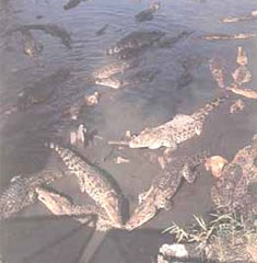 Le séjour dans cet endroit singulier permettra au voyageur de connaître des personnes bien préparées qui travaillent pour augmenter le développement des espèces, après avoir mis un frein au processus accéléré de disparition du crocodile à Cuba. Le plus grand élevage de lespèce, situé dans la Cienaga (Marécages) de Zapata, un des endroits dont la flore et la faune sont les mieux conservés, à beaucoup contribué à cette réussite. La zone très grande englobe approximativement 600 kilomètres carrés, et il est estimé quil y existe plusieurs milliers despèces cubaines. Lélevage se trouve dans un lieu nommé La Boca, qui fait partie du centre touristique de la Cienaga, lequel inclus un village Taino (Anciens indiens habitants les lieux) la Lagune du Trésor avec une pêche abondante, entre autres attractions. Les exemplaires sont soignés par des vétérinaires et dautres spécialistes qui les intègrent à la population de reptiles des marécages lorsquils atteignent lage requis.
Pour davantage d'information:
www.cuba-fauna.com
,
www.cuba-matanzas.com
|
|
|
FUERTE EL MORRILLO
 Declared a National Monument in 1978, it is a preserved military construction at the mouth of the Canimar River, in the city of Matanzas.
It is located in one of the fortresses that protected the city from the constant attacks of pirates, and it adopted its present day look around 1830.
Pieces of aborigine archaeology are on exhibit, since the fortress was constructed in the middle of the largest settlement of Cubas first inhabitants.
Two of the patriots that fought for independence: Antonio Guiteras and the Venezuelan Carlos Aponte, chose this place to organise an expedition to Mexico. After being ratted on, they were surprised and murdered on this site on May 8th of 1935.
Declared a National Monument in 1978, it is a preserved military construction at the mouth of the Canimar River, in the city of Matanzas.
It is located in one of the fortresses that protected the city from the constant attacks of pirates, and it adopted its present day look around 1830.
Pieces of aborigine archaeology are on exhibit, since the fortress was constructed in the middle of the largest settlement of Cubas first inhabitants.
Two of the patriots that fought for independence: Antonio Guiteras and the Venezuelan Carlos Aponte, chose this place to organise an expedition to Mexico. After being ratted on, they were surprised and murdered on this site on May 8th of 1935.
Pour davantage d'information:
www.cuba-architecture.com
,
www.cuba-heroes.com
,
www.cuba-history.com
,
www.cuba-matanzas.com
|
|
|
LA DOMINICA BUILDING
Built in 1849 it is located in the Plaza of Cristóbal Colón, where the city of Cardenas was founded and also its political, administrative and cultural centre, very near Varadero Beach.
This building has had several social uses and has witnessed several historical events, some of the most notable being the lodging of the generals of the Mambi army: Máximo Gómez Báez, Antonio Maceo Grajales and Domingo Méndez Capote.
When the city was taken on May 19th of 1850, by the troops of the Venezuelan General Narciso López, there was an exceptional moment in which, for the first time in history, the Cuban flag was raised.
Due to its wealth of historical merits, this building was named a National Monument.
Pour davantage d'information:
www.cuba-history.com
,
www.cuba-matanzas.com
,
www.cubanculture.info
,
www.cuban-culture.com
|
|
|
LA IGNACIA MONUMENT
This monument marks the place where the Independence War of the east was reborn on February 24th of the year of 1895. The event, known as the Cry of Ibarra (Grito de Ibarra) was organised by the National Hero José Martí from his exile and directed in this territory by two great personalities of Cubas history: Juan Gualberto Gómez and Antonio López Coloma.
This is a perpetual tribute of remembrance for the legendary fighters of the Islands freedom against the Spanish colonial yoke.
The present day monument was built in the farmstead of La Ignacia (Finca La Ignacia), a wild spot of much natural beauty that well deserves a visit in the municipality of Limonar, less than 20 kilometres from the city of Matanzas.
Due to its high historical value this place has been declared a National Monument.
Pour davantage d'information:
www.cuba-heroes.com
,
www.cuba-history.com
,
www.cuba-josemarti.com
,
www.cuba-matanzas.com
|
|
|
LE PONT DE BACUNAYAGUA
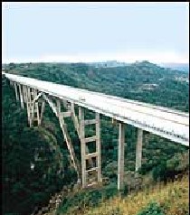 Il marque la limite par la route connue de Via Blanca entre les provinces de La Havane et de Matanzas, par conséquent les deux provinces se disputent la propriété de ce joyau de larchitecture cubaine, dune longueur de 114 mètres et dune hauteur de 110 mètres.
La construction de cette uvre fut achevée en 1960 et larche du pont fut faite en acier laminé, montées en deux parties, chacune courbée jusquà ce quelle soit dans la position permanente. Les poutres furent misent en place grâce à des armatures de lancement et pèsent chacune ni plu ni moins de 47 tonnes.
On peut considérer que cest la construction de ce type la plus complexe et la plus osée qui existe à Cuba. Le chef du projet fut lingénieur Luis Saenz Duplace.
Il marque la limite par la route connue de Via Blanca entre les provinces de La Havane et de Matanzas, par conséquent les deux provinces se disputent la propriété de ce joyau de larchitecture cubaine, dune longueur de 114 mètres et dune hauteur de 110 mètres.
La construction de cette uvre fut achevée en 1960 et larche du pont fut faite en acier laminé, montées en deux parties, chacune courbée jusquà ce quelle soit dans la position permanente. Les poutres furent misent en place grâce à des armatures de lancement et pèsent chacune ni plu ni moins de 47 tonnes.
On peut considérer que cest la construction de ce type la plus complexe et la plus osée qui existe à Cuba. Le chef du projet fut lingénieur Luis Saenz Duplace.
Pour davantage d'information:
www.cuba-giron.com
,
www.cuba-guama.com
,
www.cuba-matanzas.com
,
www.cuba-cienagadezapata.com
,
www.cuba-playagiron.com
,
www.cuba-playalarga.com
|
|
|
MATANZAS
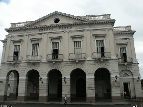 Avec le nom de San Carlos et San Severino de Matanzas, elle est fondée le 12 octobre 1693 et à actuellement une superficie de presque 12 000 kilomètres carrés et u peu plus de 700 000 habitants. Elle est connue comme lAthènes de Cuba.
La ville est traversée par le fleuve San Juan et se caractérise par son développement culturel, dont lexpression la plus significative est le théâtre Sauto où ont joué dimportantes figures nationales et internationales.
Ni la ville ni la province ne possèdent délévation significative et leurs terres sont fertiles. Pour faire une visite de la ville aux 300 ans dage il suffit de parcourir les 98 kilomètres qui la séparent de la capitale. De plus elle est un passage obligé sur le trajet vers la plage de Varadero, un des principaux pôles touristiques du pays.
La rencontre avec Matanzas permet dapprécier non seulement la beauté de sa splendide baie, mais aussi de parcourir la partie du centre de la ville où sharmonisent des parcs et des édifices qui datent pour certains de lépoque coloniale. Si vous préférez, vous pouvez vous baigner à la plage El Zapato qui baigne une frange de la ville.
Si vous voyagez depuis La Havane, vous aurez alors aussi la possibilité dapprécier dans toute sa dimension la Vallée de Yumuri, qui se trouve aux portes de la ville et une fois à lintérieure de cette dernière il est aussi conseillé une incursion dans les grottes de Bellamar, avec ses merveilleux stalactites et stalagmites.
Avec le nom de San Carlos et San Severino de Matanzas, elle est fondée le 12 octobre 1693 et à actuellement une superficie de presque 12 000 kilomètres carrés et u peu plus de 700 000 habitants. Elle est connue comme lAthènes de Cuba.
La ville est traversée par le fleuve San Juan et se caractérise par son développement culturel, dont lexpression la plus significative est le théâtre Sauto où ont joué dimportantes figures nationales et internationales.
Ni la ville ni la province ne possèdent délévation significative et leurs terres sont fertiles. Pour faire une visite de la ville aux 300 ans dage il suffit de parcourir les 98 kilomètres qui la séparent de la capitale. De plus elle est un passage obligé sur le trajet vers la plage de Varadero, un des principaux pôles touristiques du pays.
La rencontre avec Matanzas permet dapprécier non seulement la beauté de sa splendide baie, mais aussi de parcourir la partie du centre de la ville où sharmonisent des parcs et des édifices qui datent pour certains de lépoque coloniale. Si vous préférez, vous pouvez vous baigner à la plage El Zapato qui baigne une frange de la ville.
Si vous voyagez depuis La Havane, vous aurez alors aussi la possibilité dapprécier dans toute sa dimension la Vallée de Yumuri, qui se trouve aux portes de la ville et une fois à lintérieure de cette dernière il est aussi conseillé une incursion dans les grottes de Bellamar, avec ses merveilleux stalactites et stalagmites.
Pour davantage d'information:
www.cuba-giron.com
,
www.cuba-guama.com
,
www.cuba-matanzas.com
,
www.cuba-cienagadezapata.com
,
www.cuba-playagiron.com
,
www.cuba-playalarga.com
|
|
|
PARC BACONAO
 À peine 20 kilomètres le séparent de la ville de Santiago de Cuba et sa superficie est de 80 000 hectares dont lextrémité pénètre dans le territoire de Guantanamo. Le visiteur sera subjugué par la quantité de lieux qui occuperont son temps, parmi lesquels : plages, sites historiques et naturels, musées uniques en leur genre à Cuba et une grande variété doffres gastronomiques. Crée en 1981, il englobe plusieurs des principales attractions de Santiago de Cuba, comme le sont La Gran Piedra et la Granjita (La Grande Pierre et la Petite Grange) lieu doù partirent les assaillant de la caserne Moncada avec Fidel Castro à leur tête, à laube du 26 juillet 1953. Sont aussi intéressant la Vallée de la Préhistoire, le Musée de lImage ainsi que le Musée du Transport Terrestre, exposition originale intégrant plus de 2 500 pièces à échelle réduite. Vous ne devez pas manquer de dinclure à votre parcours la visite au restaurant reconnu « la Casa de Pedro el Cojo » où vous dégusterez la meilleur cuisine cubaine.
Pour davantage d'information:
www.cuba-santiagodecuba.com
|
|
|
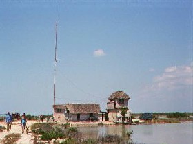
PLAGE GIRON
 Dans la célèbre Baie des Cochons, se produisit, en avril 1961, une invasion financée par le États-Unis, utilisant des personnes contraires à la Révolution cubaine. Près de 1600 mercenaires participèrent au débarquement, déroutés en moins de 72 heures. Cet événement historique marqua le premier échec militaire des États-Unis en Amérique Latine et son conservés sur les lieux de nombreux témoignages et des témoins directs des événements vivent là. Sont montrés, en plus, dans le musée qui se trouve dans lancienne usine de production de sucre « Central Australia » de valeureux documents déclassés de lAgence Centrale dIntelligence (CIA), ainsi que des armes et des objets de tout type confisqués aux plus de mille prisonniers.
Pour davantage d'information:
www.cuba-giron.com
,
www.cuba-history.com
,
www.cuba-matanzas.com
,
www.cuba-playagiron.com
|
|
|
REMAINS OF THE TRAIL (TROCHA) FROM JÚCARO TO MORÓN
A brief history of the Trail (Trocha) from Júcaro to Morón.
In the wars of 1868 and 1895, the Trocha was an insurmountable barrier, as the Spanish thought, and after it was finished, it became the most perfect and sophisticated military construction that the Spanish Colonialism had in America. Of course it was never a deterrent for the glorious Mambi Army (Ejército Mambí), who in both wars kept crossing it ,showing the ingenious strategies deployed by their military chiefs, among them Máximo Gómez and Antonio Maceo, with the help of other insurrectional chiefs of the area, such as Brigadier José Gómez Cardoso and Colonel Simón Reyes Hernández, known as the Eagle of the Trocha (El Águila de la Trocha).
The aim of this military line was to isolate the mambi forces in the eastern area, in order to deter help and break contact between the insurrectional forces in the central and eastern regions, and to stop the invaders, led by Máximo Gómez and Antonio Maceo from extending the war to the western region of the country, an event that would wear down the strength of Spanish colonialism, leading up to its final fall.
By the end of March of 1871, three years from the Cry of Yara (Grito de Yara), General Blas Villate de la Hera, Count of Valmaseda, proposed to the Overseas Minister of the Spanish Crown; the construction of a trocha or fortified line, from the port of Júcaro, on the southern coast; running across the island, to the settlement of Morón, on the northern coast.
Valmasedas proposal was approved, and construction on the trocha was started. It started out with 17 fortresses and in 1874, 16 bunkers had been added on, more than five thousand men were employed to guard it, these soldiers had modern infantry weapons as well as ten pieces of artillery, which were moved along the Trocha by a narrow railway, which also allowed them to quickly move the troops from one end to the other.
Pour davantage d'information:
www.cuba-heroes.com
,
www.cuba-history.com
,
www.cuba-matanzas.com
,
www.cuba-cienfuegos.com
,
www.cuba-villaclara.com
,
www.cuba-sanctispiritus.com
|
|
|
STADE PALMAR DE JUNCO
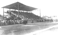 Il se trouve actuellement au cur de la ville de Matanzas, capitale de la province homonyme, à 100 kilomètres de la Ville de La Havane. Il fut construit en 1847 et thésaurise le prix historique davoir reçu en 1874 la première partie de baseball joué à Cuba. Il à été projeté de faire ici le Salon de des Célébrités de ce sport dans lîle, à partir de tout ce que signifie cette vétuste installation où eurent lieu des parties de baseball des premières rencontres nationales organisées après le triomphe de la Révolution en 1959, jusquà ce que les rencontres soient transférées au nouveau stade Victoire de Giron. Siège actuel des équipes du territoire.
Pour davantage d'information:
www.cuba-history.com
,
www.cuba-matanzas.com
|
|
|
TRIUNVIRATO
This monument erected in memory of the Rebel Slave (Esclavo Rebelde) is found on the land belonging to the ancient sugar mill of Triunvirato, founded in the XIX century, a period in which many sugar mills were set up and started functioning in the Matanzas area.
Precisely here, events of such transcendental importance took place on November fifth of 1843, that they provoked the burst of the greatest rebellion ever in those convulsive times of slavery.
These violent events brought about the initial execution of the foreman, an evil man that had much abused his victims and following that event, the slaves set the whole place on fire, devouring even the last wooden plank of Triunvirato.
This monument speaks for itself. There are more than enough historical reasons for it to have a privileged place among those that are considered National Monuments.
Pour davantage d'information:
www.cuba-history.com
,
www.cuba-sugar.com
,
www.cuba-matanzas.com
|
|
|
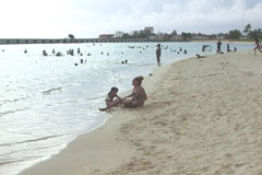
VARADERO
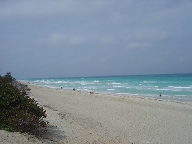 Elle est considéré comme une des plages les plus belles du monde et se trouve sur la péninsule de Icacos avec ses 22 kilomètres dadmirable combinaison de sable blanc et fin et de mer aux couleurs diverses. Cette station balnéaire est fréquentée chaque année par des centaines de milliers de personnes provenant des quatre coins du globe.
Elle rempli toutes les conditions requises pour satisfaire les goûts les plus exigeants, depuis son moderne aéroport international Juan Gualberto Gómez, jusquà près de 15 000 chambres réparties dans de modernes et confortables hôtels opéré par les plus connues des entreprises cubaines et dautres célèbres sociétés spécialisées de divers pays.
Lexploitation de ce pôle touristique à commencé dans les années 40, mais la date exacte de sa fondation remonte au 5 décembre 1887, lorsque dix familles sinstallèrent dans la région. Depuis lors les changements qui ont eu lieu à Varadero sont énormes et sont en constante évolution.
Elle est considéré comme une des plages les plus belles du monde et se trouve sur la péninsule de Icacos avec ses 22 kilomètres dadmirable combinaison de sable blanc et fin et de mer aux couleurs diverses. Cette station balnéaire est fréquentée chaque année par des centaines de milliers de personnes provenant des quatre coins du globe.
Elle rempli toutes les conditions requises pour satisfaire les goûts les plus exigeants, depuis son moderne aéroport international Juan Gualberto Gómez, jusquà près de 15 000 chambres réparties dans de modernes et confortables hôtels opéré par les plus connues des entreprises cubaines et dautres célèbres sociétés spécialisées de divers pays.
Lexploitation de ce pôle touristique à commencé dans les années 40, mais la date exacte de sa fondation remonte au 5 décembre 1887, lorsque dix familles sinstallèrent dans la région. Depuis lors les changements qui ont eu lieu à Varadero sont énormes et sont en constante évolution.
Pour davantage d'information:
www.cuba-giron.com
,
www.cuba-guama.com
,
www.cuba-matanzas.com
,
www.cuba-cienagadezapata.com
,
www.cuba-playagiron.com
,
www.cuba-playalarga.com
|
|